
Services
At Gita Fanavar Hosh-Gostar Pars, we integrate Artificial Intelligence (AI), Geospatial Intelligence (GI), and Geospatial Artificial Intelligence (GeoAI) to deliver scientific, data-driven, and innovative solutions for analyzing, understanding, and managing spatial phenomena.
By leveraging advanced technologies such as machine learning, satellite image processing, GIS, SDI, Big Data, and IoT, we provide accurate, sustainable, and internationally standardized services.
Global Distribution of Products
Introduction to Selected Products
Research and Implementation Projects
Geographical Intelligent Technology Advisers (GITA) Gita Fanavar HoushGostar Pars was founded with a focus on integrating artificial intelligence and geospatial sciences to develop innovative solutions in the field of Geospatial Intelligence (GI). Established by a team of young and experienced specialists at the Guilan Science and Technology Park, the company is dedicated to transforming spatial data into intelligent insights that support more accurate decision-making in urban planning, environmental management, transportation, and resource governance.
At GITA, we combine cutting-edge technologies in machine learning, spatial analytics, and satellite image processing to help build a smarter and more sustainable future—where location, meaning, and data come together.
The company’s main activities include:
- Spatial data analysis using Geospatial Intelligence (GI) and Geographical Artificial Intelligence (GeoAI)
- Development of geospatial systems and applications powered by Artificial Intelligence (AI)
- Consulting and specialized services based on Big Data and the Internet of Things (IoT)
About


Address
Room 106, Growth Center, University of Guilan Campus, Mellat Street, Rasht, Guilan, Iran
Phone
+98 13 33341956
Postal Code
41447-84475
Contact us via
the contact form.
Contact
Our address
University of Guilan Campus, Mellat Street, Rasht, Guilan


Follow us on social media


Geographical Intelligent Technology Advisers (GITA)
Links
All rights to the site belong to Geographical Intelligent Technology Advisers Company.
Contact
Room 106, Growth Center, University of Guilan Campus, Mellat Street, Rasht, Guilan, Iran – Postal Code: 41447-84475
IVR Analyzer
تکنولوژی های مورد استفاده:
Python , Node.js, Angular, JWT, Cloud Technologies , Serverless , Bitbucket pipeline Dolby جهت آنالیز صدا, پردازش زبان با wink-nlp , VOIP با استفاده از سرویس Vonage (تماس بر بستر اینترنت)
با استفاده از تکنولوژی های روز دنیا اعم از هوش مصنوعی، پردازش زبان های طبیعی و سرویس های ابری این امکان را برای کاربران فراهم می سازد تا یک گزارش کامل از کیفیت عملکرد در زمینه های مختلف از جمله (کیفیت تماس، کیفیت صدا، پیچیدگی دسترسی به خدمات و آنالیز سایر شاخص های کمی و کیفی) تلفن های گویای شرکت و سازمان برای ارائه خدمات بهتر به مشتری دریافت نمایند.
Plan Share
مهندسانی که فایل های pdf متعدد و بزرگ حاوی نقشه های ساختمان دارند، می توانند روی دستگاه های قابل حمل مانند تبلت، موبایل و لپ تاپ این فایل ها را تحت وب ملاحظه کنند و ویرایش هایی روی آن ها انجام دهند. این ویرایش ها شاملcrop, concatenate و امکان ترکیب pdf های مختلف می شود. همچنین امکان به اشتراک گذاری، versioning، ذخیره draft، قفل گذاشتن و تعیین سطح دسترسی فراهم شده است.
تکنولوژی های مورد استفاده:
Python, Go Lang, Angular, JWT, Cloud Technologies, Serverless, Bitbucket pipeline, Conva.js, Microservice architecture
Auth Core
تکنولوژی های مورد استفاده:
Java, Keycloak
احراز هویت یکپارچه یا ورود یکپارچه (Single Sign-On) نوعی رویکرد کنترل دسترسی به سامانههای نرمافزاری مرتبط است که به صورت مستقل از یکدیگر سازماندهی شدهاند. با استفاده از این ویژگی، کاربر از طریق یک نامکاربری و رمزعبور مشخص احراز هویت شده و پس از آن میتواند به تمامی سامانههای متصل به احراز هویت یکپارچه دسترسی داشته باشد. مثال واضحی از کاربرد این ویژگی، سامانههایی هستند که جهت دسترسی به هر بخش نیازمند احراز هویت کاربر هستند اما با استفاده از احراز هویت یکپارچه از اعتبارنامه یکسان قرار داده شده در سروری به نام دایرکتوری سرور احراز هویت (Directory Server Authentication) استفاده میکنند. در این حالت، دایرکتوری سرور با تنها یک بار تایید هویت کاربر از طریق ارسال یکپارچه توکن احراز هویت مختص به آن کاربر، زمینه دسترسی او به برنامهها و بخشهای مختلف سامانه را فراهم میکند. در واقع برنامههای کاربردی مختلف قرار داده شده در این نوع سامانهها به صورت سامانه احراز هویت یکپارچه پیکربندی شدهاند. بخش دیگری از سامانه احراز هویت یکپارچه، خروج یکپارچه (Single Sign-Off) است که به موجب آن، تنها یک عمل خروج از پروفایل سبب قطع شدن دسترسی کاربر به تمامی سامانههایهای نرم افزاری متصل به احراز هویت یکپارچه میشود.
قابلیت های سیستم به طور خلاصه عبارت اند از:
ورود و خروج یکپارچه - واسط تأیید هویت و ورود از طریق حساب کاربری شبکههای اجتماعی - تجمیع (Federation) کاربر - میز (Console) مدیریت - میز مدیریت حساب کاربری مخصوص کاربران عادی - پشتیبانی از اغلب پروتکلهای استاندارد احراز هویت
IoTrix
تکنولوژی های مورد استفاده:
Go language, Cloud Technologies, Serverless, Bitbucket Pipelines, InfluxDB, Runscope, Microservice architecture
این محصول دارای داشبورد مدیریت و مانیتورینگ ابزارهای حسگر (دما، فشار، سرعت و ...) الکترونیکی IOT است که امکان حذف و اضافه حسگرها و مانیتورینگ آنها را برای مدیر سیستم در قبال همه ابزارهای همه مشتریان فراهم می آورد. ضمنا هر مشتری هم امکان حذف و اضافه و مانیتورینگ حسگرهای مخصوص خود را دارد. محصول دارای سیستم مجزای گزارش گیری بر اساس پارامترهای مختلف مورد نظر کاربر است.
RecomMind
تکنولوژی های مورد استفاده:
Java, Python, React, PostgreSQL, Microservice architecture
مواجهه با مسئله حجم بالاى اطلاعات همواره از موضوعات قابل توجه در تحقيقات علمى بوده است و يكى از رويكردهاى موجود در اين زمينه استفاده از سیستمهای توصیه گر است. سيستمهای توصيه گَر رويكردی برای رویارویی با حجم بسيار زياد اطلاعات بوده و به كاربر اين امكان را مى دهند تا با سرعت بيشترى به مقصود خود برسد. با وجود فراگیر شدن این سیستمها در زمینه های گوناگون، مطالعات نياز به توجه بيشتر به بکارگیری آنها در پایگاههای علمی را نشان می دهند. در اين محصول با بکاركیری یک مدل هوشمند، این امكان وجود كه محصولات و موارد متعدد مورد نياز كاربر در اختیار قرار گیرد و نیازهای کاربران به سادگی مرتفع شوند.
روحاله اوجی
• دانشیار گروه جغرافیای دانشگاه گیلان
• دكتری اقليم شناسی از دانشگاه تربيت مدرس
• دروه فرصت مطالعاتی، کنسرسیوم اثرات آب و هوایی اقیانوس آرام، دانشگاه ویکتوریا، بریتیش کلمبیا، کانادا
• دوره کارشناسی ارشد، دانشگاه UN، توکیو، ژاپن
• عضو هسته پژوهشی GIS&Rs دانشگاه گیلان
• کارشناس، سازمان نقشه برداری کشور (۱۳۹۳-۱۳۸۶)
سید ابولقاسم میرروشندل
• دانشیار گروه مهندسی کامپیوتر دانشگاه گیلان
• دکتری کامپیوتر – هوش مصنوعی از دانشگاه Aix-Marseille فرانسه
• دکتری مهندسی کامپیوتر – هوش مصنوعی از دانشگاه صنعتی شریف
• فرصت مطالعاتی با عنوان بهبود و به کارگیری مدلهای زبانی بزرگ در کاربردهای هوش مصنوعی"، دانشگاه استونی بروک، نیویورک، آمریکا
2
Satellite and Aerial Image Processing and Interpretation
• Production of thematic maps and geospatial information layers # • Monitoring land-use/land-cover changes, cropping patterns, erosion, floods, and droughts # • Development of intelligent tools for automated image classification, detection, and interpretation
1
Geospatial Data Analysis and Spatial Intelligence (GI & GeoAI)
• Extraction of spatial patterns, trends, and predictive insights # • Decision-support analyses for urban management, environment, water resources, energy, and agriculture # • Development of intelligent models based on machine learning and spatial neural networks
4
Spatial Data Infrastructure (SDI) Development and Implementation
• Design of data models, metadata frameworks, standardization, and system integration # • Development of spatial databases, large-scale geodatabases, and WMS/WFS services # • Consultancy in spatial information architecture design for large organizations
RecomMind
Technologies Used:
Java, Python, React, PostgreSQL, Microservice Architecture
Addressing the challenge of large-scale data has always been a critical issue in scientific research, and one of the effective approaches in this field is the use of recommender systems. Recommender systems provide a solution for managing vast volumes of information and enable users to reach their desired content more efficiently. Despite the widespread adoption of such systems in various domains, studies indicate that their application in scientific databases still requires greater attention.
In this product, by employing an intelligent model, users are provided with relevant items and resources tailored to their needs, allowing them to quickly and easily access the most appropriate results and effectively meet their information requirements.
IoTrix
Technologies Used:
Go Language, Cloud Technologies, Serverless Architecture, Bitbucket Pipelines, InfluxDB, Runscope, Microservice Architecture
IoTrix is an advanced IoT device management and monitoring platform designed to provide comprehensive oversight of sensor-based electronic systems. The platform offers a centralized dashboard through which system administrators can add, remove, and monitor various sensors—such as temperature, pressure, and speed—across all devices and clients.
Each client also benefits from an independent management interface, allowing them to configure, manage, and monitor their own dedicated sensors. Additionally, IoTrix includes a fully customizable reporting module, enabling users to generate detailed analytical reports based on specific operational parameters.
Auth Core
Technologies Used:
Java, Keycloak
Auth Core is a unified authentication solution designed to streamline secure access across multiple software systems. By implementing Single Sign-On (SSO), users can authenticate once with a single set of credentials and subsequently gain access to all integrated applications without repeated logins.
The system relies on a centralized Directory Server Authentication mechanism, which issues a unique authentication token for each verified user, enabling seamless interaction with various connected services. Auth Core also supports Single Sign-Off (SSO-ff), ensuring that logging out from one session terminates access across all linked systems.
Key system capabilities include unified login and logout, social login integration, user federation, an administrative management console, a self-service user account dashboard, and support for major industry-standard authentication protocols.
Plan Share
Technologies Used:
Python, Go Lang, Angular, JWT, Cloud Technologies, Serverless Architecture, Bitbucket Pipeline, Conva.js, Microservice Architecture
Plan Share is a web-based platform designed for engineers and technical professionals who work with large and complex PDF files containing architectural and structural plans. The system enables users to view, manage, and edit these files seamlessly on portable devices such as tablets, mobile phones, and laptops.
Available editing features include cropping, concatenating, and merging multiple PDF documents. In addition, the platform supports secure file sharing, version control, draft saving, access-level management, and document locking—ensuring efficient collaboration and streamlined project workflows.
IVR Analyzer
Technologies Used:
Python, Node.js, Angular, JWT, Cloud Technologies, Serverless Architecture, Bitbucket Pipeline, Dolby (for audio analysis), wink-nlp (for NLP processing), VOIP via Vonage (Internet-based telephony)
IVR Analyzer is an intelligent system designed to evaluate and optimize the performance quality of interactive voice response (IVR) services. Utilizing cutting-edge technologies—including artificial intelligence, natural language processing, and cloud-based architectures—the platform provides comprehensive analytical reports on various performance indicators such as call quality, audio clarity, service accessibility complexity, and other quantitative and qualitative metrics.
This enables organizations to enhance their IVR systems and deliver a superior customer experience.
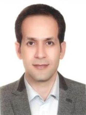
Esmaeil Aghaeizadeh
• Associate Professor, Department of Geography, University of Guilan
• Ph.D. in Geography and Urban Planning, Kharazmi University
• Research Fellowship: “Gentrification Theory in Urban Deteriorated Fabrics,” University of Gothenburg, Sweden
• Director, Urban Planning Studio, Arman Shar Consulting Engineers (2005–2011)
• Member of the GIS & RS Research Core, University of Guilan
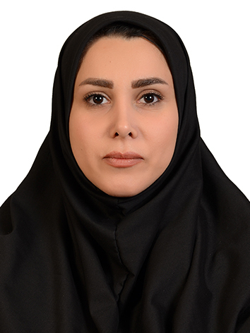
Ruhollah Oji
• Associate Professor, Department of Geography, University of Guilan
• Ph.D. in Climatology, Tarbiat Modares University
• Research Fellowship, Pacific Climate Impacts Consortium, University of Victoria, British Columbia, Canada
• M.Sc. Program, United Nations University (UNU), Tokyo, Japan
• Member of the GIS & RS Research Core, University of Guilan
• Expert (former), National Cartographic Center of Iran (2007-2014)
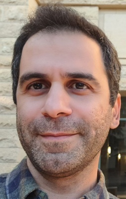
Seyed Abolghasem Mirroshandel
• Associate Professor, Department of Computer Engineering, University of Guilan
• Ph.D. in Computer Science – Artificial Intelligence, Aix-Marseille University, France
• Ph.D. in Computer Engineering – Artificial Intelligence, Sharif University of Technology
• Research Fellowship: “Improvement and Application of Large Language Models in Artificial Intelligence,” Stony Brook University, New York, USA